Mercator projection
32 results back to index

pages: 481 words: 121,300
Why geography matters: three challenges facing America : climate change, the rise of China, and global terrorism by Harm J. De Blij
agricultural Revolution, airport security, Anton Chekhov, Ayatollah Khomeini, Berlin Wall, British Empire, colonial exploitation, complexity theory, computer age, crony capitalism, demographic transition, Deng Xiaoping, Eratosthenes, European colonialism, F. W. de Klerk, failed state, Fall of the Berlin Wall, Francis Fukuyama: the end of history, global village, Great Leap Forward, high-speed rail, illegal immigration, Internet Archive, John Snow's cholera map, Khyber Pass, manufacturing employment, megacity, megaproject, Mercator projection, MITM: man-in-the-middle, Nelson Mandela, Oklahoma City bombing, out of africa, RAND corporation, risk tolerance, Ronald Reagan, social distancing, South China Sea, special economic zone, Thomas Malthus, trade route, transatlantic slave trade, UNCLOS, UNCLOS
Magellan and his crew were the first to circumnavigate the world (1519-1522), building on Cabral's impressions of the coast of Brazil and proving the vastness of the Pacific; the Italian Battista Agnese's 1544 map of the world was soon renowned for its beauty as well as its novelty; and the Flemish mathematician and cartographer Gerardus Mercator formulated a grid for the evolving map of the world that allowed navigators to plot a straight-line compass bearing, the Mercator Projection (1569). This was a momentous innovation, and the name Mercator remains famous to this day—as well as another of his inventions, the concept of the atlas (which he named after a Greek titan) as a collection of maps. 23 24 WHY GEOGRAPHY MATTERS It is well to remember, however, that Europeans were not the only map-makers of the time.
…
MAP PROJECTIONS This brings us to the interesting topic of map projections. Earlier 1 mentioned Mercator and his milestone navigation-friendly projection, without saying exactly what a map "projection" is but pointing out that projections inevitably distort the reality on the ground (Greenland's huge size on the Mercator projection is a case in point). The fact is that you can manipulate map projections to exaggerate, diminish, distort, and otherwise modify any representation of any part of the Earth's surface. Countries can be made to look larger, compared to others, than they really are. Places can be made to look closer to you than they really are.
…
The parallels and meridians would throw shadows onto the paper, creating a kind of READING MAPS AND FACING THREATS 33 projection—not a usable one, but now it becomes a matter of manipulating the light source or the paper. If you put a neon tube inside, pole to pole, you would get something close to the Mercator projection. If you made a conical "hat" of the paper and put it on the Northern Hemisphere, rather than a cylinder all around the globe, you would get less distortion—but only half the world. Indeed, some projections are called "cylindrical" and others "conical." If you want to produce a comparatively low-distortion map of the United States, you would use a conical projection (Fig. 2-3).
Python Geospatial Development - Second Edition by Erik Westra
business logic, capital controls, database schema, Firefox, functional programming, Golden Gate Park, Google Earth, Mercator projection, natural language processing, openstreetmap, Silicon Valley, systems thinking, web application
Cylindrical projections An easy way to understand cylindrical projections is to imagine that the earth is like a spherical Chinese lantern, with a candle in the middle: If you placed this lantern-earth inside a paper cylinder, the candle would "project" the surface of the earth onto the inside of the cylinder: You can then "unwrap" this cylinder to obtain a two-dimensional image of the earth: Of course, this is a simplification—in reality, map projections don't actually use light sources to project the earth's surface onto a plane, but instead use sophisticated mathematical transformations to achieve the same effect. Some of the main types of cylindrical projections include the Mercator Projection, the Equal-Area Cylindrical Projection, and the Universal Transverse Mercator Projection. The following map, taken from Wikipedia, is an example of a Mercator projection: Conic projections A conic projection is obtained by projecting the earth's surface onto a cone: The cone is then "unwrapped" to produce the final map. Some of the more common types of conic projections include the Albers Equal-Area Projection, the Lambert Conformal Conic Projection, and the Equidistant Projection.
…
Proj Proj is a cartographic transformation class, allowing you to convert geographic coordinates (that is, latitude and longitude values) into cartographic coordinates (x, y values, by default in meters) and vice versa. When you create a new Proj instance, you specify the projection, datum, and other values used to describe how the projection is to be done. For example, to use the Transverse Mercator projection and the WGS84 ellipsoid, you would do the following: projection = pyproj.Proj(proj='tmerc', ellps='WGS84') Once you have created a Proj instance, you can use it to convert a latitude and longitude to an (x, y) coordinate using the given projection. You can also use it to do an inverse projection—that is, converting from an (x, y) coordinate back into a latitude and longitude value again.
…
So let's start by downloading some geospatial data in Universal Transverse Mercator (UTM) projection. The WebGIS website (http://webgis.com) provides shapefiles describing land-use and land-cover, called LULC datafiles. For this example, we will download a shapefile for southern Florida (Dade County, to be exact), which uses the Universal Transverse Mercator projection. You can download this shapefile from the following URL: http://webgis.com/MAPS/fl/lulcutm/miami.zip The decompressed directory contains the shapefile, called miami.shp, along with a datum_reference.txt file describing the shapefile's coordinate system. This file tells us the following: The LULC shape file was generated from the original USGS GIRAS LULC file by Lakes Environmental Software.

pages: 385 words: 103,561
Pinpoint: How GPS Is Changing Our World by Greg Milner
Apollo 11, Ayatollah Khomeini, Boeing 747, British Empire, creative destruction, data acquisition, data science, Dava Sobel, different worldview, digital map, Easter island, Edmond Halley, Eratosthenes, experimental subject, Eyjafjallajökull, Flash crash, friendly fire, GPS: selective availability, Hedy Lamarr / George Antheil, Ian Bogost, Internet of things, Isaac Newton, John Harrison: Longitude, Kevin Kelly, Kwajalein Atoll, land tenure, lone genius, low earth orbit, Mars Rover, Mercator projection, place-making, polynesian navigation, precision agriculture, race to the bottom, Silicon Valley, Silicon Valley startup, Skinner box, skunkworks, smart grid, systems thinking, the map is not the territory, vertical integration
As any user of etak (the ancient Pacific navigational aid, not the 1980’s proto-GPS car guidance system) will tell you, this is a view of the world completely at odds with the way parallels and meridians behave on the earth’s curved surface, and grossly distorts the size of land masses the closer they are to the poles. The Mercator projection remained popular throughout the centuries. In the 1980s, cartographical societies drafted a resolution that discouraged any further use of it, in favor of equal-area maps, which more accurately depict the relative size of land masses. Around the same time, the first mass-market computerized maps appeared. Some used the Mercator projection, others did not, and well into the 1990s there was no clear preference. For Google Maps, which appeared in 2005 and soon became the world’s most accessible GIS, the Mercator projection was an obvious choice. At every point on a Mercator map, “north” points in exactly the same direction, making it more suitable for panning and zooming.
…
In a strange city, with no map or GPS, we remember how many blocks we have ventured from the hotel; we locate ourselves in relation to prominent landmarks. But mostly, in the age of GPS, we don’t require the environment to locate ourselves. Imagine trying to convince a literal-minded Martian anthropologist—or the Carolinian navigator—why the first mapped image of the world many children study is the Mercator projection that is still a staple of grade-school classrooms, with its grotesque geographic distortions. Or why the X on a shopping mall’s map, labeled “you are here,” does not imply a belief that you are actually, you know, there, engraved on that map, anchored for eternity. Lewis suspected that Tevake used a reference system similar to etak, one that allowed him to conceptualize where he was in relation to islands in the region.
…
But to say that GIS helps a GPS receiver know the real world—knowledge it then imparts to us, the users—is not quite right. Like any map, the GIS component of GPS offers an actively mediated representation of the world. GPS therefore constructs its own version of the world, not a mirror image of “reality.” To represent geographic data, Google Maps uses the Mercator projection, named after the sixteenth-century cartographer Gerardus Mercator, which represents latitude and longitude as being perfectly perpendicular. Sailors and navigators liked this projection because a ship on a steady bearing was represented by a straight line on the map. As any user of etak (the ancient Pacific navigational aid, not the 1980’s proto-GPS car guidance system) will tell you, this is a view of the world completely at odds with the way parallels and meridians behave on the earth’s curved surface, and grossly distorts the size of land masses the closer they are to the poles.

pages: 665 words: 159,350
Shape: The Hidden Geometry of Information, Biology, Strategy, Democracy, and Everything Else by Jordan Ellenberg
Albert Einstein, AlphaGo, Andrew Wiles, autonomous vehicles, British Empire, Brownian motion, Charles Babbage, Claude Shannon: information theory, computer age, coronavirus, COVID-19, deep learning, DeepMind, Donald Knuth, Donald Trump, double entry bookkeeping, East Village, Edmond Halley, Edward Jenner, Elliott wave, Erdős number, facts on the ground, Fellow of the Royal Society, Geoffrey Hinton, germ theory of disease, global pandemic, government statistician, GPT-3, greed is good, Henri Poincaré, index card, index fund, Isaac Newton, Johannes Kepler, John Conway, John Nash: game theory, John Snow's cholera map, Louis Bachelier, machine translation, Mercator projection, Mercator projection distort size, especially Greenland and Africa, Milgram experiment, multi-armed bandit, Nate Silver, OpenAI, Paul Erdős, pets.com, pez dispenser, probability theory / Blaise Pascal / Pierre de Fermat, Ralph Nelson Elliott, random walk, Rubik’s Cube, self-driving car, side hustle, Snapchat, social distancing, social graph, transcontinental railway, urban renewal
He is known today for the one he made in 1569, which he called Nova et Aucta Orbis Terrae Descriptio ad Usum Navigantium Emendata (“New and Expanded World Map Corrected for Sailors”) and which we now call the Mercator projection. Mercator’s map was good for sailors because what mattered to them wasn’t taking the absolutely shortest route; what mattered to them was not getting lost. At sea, you can use a compass to keep yourself at a fixed angle to the north (or at least the magnetic north, which is hopefully not too far off). In a Mercator projection, north-south lines of longitude are vertical lines, latitudes are horizontal, and all angles on the map are the same as they are in real life.
…
Indeed, Mercator cut his off at parallels well short of the poles to avoid the painfully apparent Arctic and Antarctic distortions. Latitude lines near the poles get farther and farther apart on the map, while in real life they’re separated by the same distance. That makes things in the polar region look bigger than they really are. In the Mercator projection, there’s as much Greenland as there is Africa. In reality, Africa is fourteen times bigger. Couldn’t there be a better projection? You might want great circles to show up as straight lines (a gnomonic projection) and you might want the relative areas of geographic objects to match real life (an authalic projection) and you might want the projection to get angles right (a conformal projection, of which Mercator’s is one).
…
From this point of view, it hardly seems unfair that Wyoming has two senators—look how much Wyoming there is! But this, of course, is an artifact of the way we draw the map. Senators represent people, not acres. We’ve already encountered the “too much Greenland” problem—standard maps like the Mercator projection distort areas, making some regions look bigger than the space they actually take up on the globe. What if there was a map that assigned each state an amount of space according to its population instead of its area, more accurately rendering the people the Senate is supposed to represent? Geometry can do that.

The Spirit of ST Louis by Charles A. Lindbergh
Charles Lindbergh, intangible asset, Mercator projection, sugar pill
We've never had a request for them before." That means a trip up north. I'll try to borrow one of the Ryan Company's monoplanes. 10 The store at San Pedro has drawers of charts that apparently cover all the earth's salt water. "I think these are what you want." The salesman pulls out two oblong sheets. They're Mercator's projections and --yes, I'm in luck -- they extend inland far enough to include New York and Paris. Then, like stumbling over a nugget of gold, I see a gnomonic projection covering them both. "A great circle on the earth's surface translates into a curve on a Mercator's chart, but it becomes a straight line on a gnomonic projection" -- I remember learning that in the Army's navigation class.
…
My navigating problems have begun to clarify. I found, printed on the charts I bought, ample instructions for laying out my great-circle route. With the instruments Hall loaned me, I drew a straight line between New York and Paris on the gnomonic projection. Then I transferred points from that line, at hundred-mile intervals, to the Mercator's projection, and connected these points with straight lines. At each point, I marked down the distance from New York and the magnetic course to the next change in angle. I chose hundred-mile intervals as convenient distances to work with because, wind and cruising speed considered, it seems likely that the Spirit of St.
…
After spending several days at this task, I reach a point in the Atlantic twelve hundred miles beyond the coast of Newfoundland. My mathematical route and my charted route coincide so closely that it seems time wasted to continue with the calculations. I have satisfied myself that the headings I marked on the Mercator's projections are correct; and there are other problems which demand attention. Now that I have my courses laid out properly, I must be sure I can hold them -- over the ocean -- over fog -- at night -- and with unknown wind drifts. Should I buy a sextant and study celestial navigation? But could I handle a sextant at the same time I'm flying a plane?

PostGIS in Action by Regina O. Obe, Leo S. Hsu
business logic, call centre, crowdsourcing, database schema, Debian, domain-specific language, en.wikipedia.org, Firefox, functional programming, Google Earth, job automation, McMansion, Mercator projection, Network effects, null island, openstreetmap, planetary scale, profit maximization, Ruby on Rails, Skype, South of Market, San Francisco, SQL injection, traveling salesman, web application
If you try to optimize for shape and to cover a large range, your measurements may be off, perhaps way off. There are a few flavors of projections you can use to optimize for different things: Cylindrical projections —Imagine a piece of paper rolled around the globe, imprinting the globe on its surface. Then you unroll it to make it flat. The most common of these is the Mercator projection, which has the bottom of the rolled cylinder parallel to the equator. This results in great distortion at the polar regions, with measurement accuracy better the closer you are to the equator, because there the approximation of flat is most accurate. Conic projections —These are sort of like cylindrical projections, except you wrap a cone around the globe, take the imprint of the globe on the cone, and then roll it out.
…
You can’t use them for the polar regions. Mercator —These are good for maintaining shape and direction and spanning the globe, but they’re not good for measurement, and they make the regions near the poles look huge. The measurements you get from them are nothing less than cartoonish, depending on where you are. The most common Mercator projections in use are variants of World Mercator (SRID 3395) or Spherical Mercator (a.k.a. Google Mercator (SRID 900913)), which is now an EPSG standard with EPSG:3857 (but for a time was EPSG:3785). This last one is fairly new, so you may not find it in your spatial_ref_sys table if your PostGIS version is older.
…
Although the transformation process is fairly cheap, it can quickly become taxing with the more data you pull, the more users hitting your database, or the greater number of points you have in a geometry. Not as many tools support geography. In theory, though, any tool that just uses the ST_AsBinary and other output functions of PostGIS geometries will work fine with geography without any change. 3.2.3. Mapping just for presentation Although the basic Mercator projections are horrible for measurement calculations, especially far from the equator, they’re a favorite for web mappers because they look good on a map. The advantage of Google Mercator, for example, is that the whole globe is covered with just one spatial reference system. So if your primary concern is looking good on a map and overlaying Google Maps with something like OpenLayers, Leaflet, or some other JavaScript API, Mercator isn’t a bad option for native data storage.

pages: 124 words: 40,697
The Grand Design by Stephen Hawking, Leonard Mlodinow
airport security, Albert Einstein, Albert Michelson, anthropic principle, Arthur Eddington, Buckminster Fuller, conceptual framework, cosmic microwave background, cosmological constant, dark matter, fudge factor, invention of the telescope, Isaac Newton, Johannes Kepler, John Conway, John von Neumann, Large Hadron Collider, luminiferous ether, Mercator projection, Richard Feynman, Stephen Hawking, Thales of Miletus, the scientific method, Turing machine
M-theory is not a theory in the usual sense. It is a whole family of different theories, each of which is a good description of observations only in some range of physical situations. It is a bit like a map. As is well known, one cannot show the whole of the earth’s surface on a single map. The usual Mercator projection used for maps of the world makes areas appear larger and larger in the far north and south and doesn’t cover the North and South Poles. To faithfully map the entire earth, one has to use a collection of maps, each of which covers a limited region. The maps overlap each other, and where they do, they show the same landscape.
…
The different theories in the M-theory family may look very different, but they can all be regarded as aspects of the same underlying theory. They are versions of the theory that are applicable only in limited ranges—for example, when certain quantities such as energy are small. Like the overlapping maps in a Mercator projection, where the ranges of different versions overlap, they predict the same phenomena. But just as there is no flat map that is a good representation of the earth’s entire surface, there is no single theory that is a good representation of observations in all situations. We will describe how M-theory may offer answers to the question of creation.

PostGIS in Action, 2nd Edition by Regina O. Obe, Leo S. Hsu
business logic, call centre, crowdsourcing, database schema, Debian, domain-specific language, en.wikipedia.org, Firefox, functional programming, Google Earth, job automation, McMansion, megacity, Mercator projection, Network effects, null island, openstreetmap, planetary scale, profit maximization, Ruby on Rails, Skype, South of Market, San Francisco, SQL injection, traveling salesman, web application
If you try to optimize for shape and to cover a large range, your measurements may be off, perhaps way off. There are a few flavors of projections you can use to optimize for different things: Cylindrical projections—Imagine a piece of paper rolled around the globe, imprinting the globe on its surface. Then you unroll it to make it flat. The most common of these is the Mercator projection, which has the bottom of the rolled cylinder parallel to the equator. This results in great distortion at the polar regions, with measurement accuracy better the closer you are to the equator, because there the approximation of flat is most accurate. Conic projections—These are sort of like cylindrical projections, except you wrap a cone around the globe, take the imprint of the globe on the cone, and then roll it out. Azimuthal projections—You project a spherical surface onto a plane tangential to the spheroid.
…
You can’t use them for the polar regions. Mercator—These are good for maintaining shape and direction and spanning the globe, but they’re not good for measurement, and they make the regions near the poles look huge. The measurements you get from them are nothing less than cartoonish, depending on where you are. The most common Mercator projections in use are variants of World Mercator (SRID 3395) or Spherical Mercator (a.k.a. Google Mercator (SRID 900913)), which is now an EPSG standard with EPSG:3857 (but for a time was EPSG:3785). This last one is fairly new, so you may not find it in your spatial_ref_sys table if your PostGIS version is older.
…
Although the transformation process is fairly cheap, it can quickly become taxing with the more data you pull, the more users hitting your database, or the greater number of points you have in a geometry. Not as many tools support geography. In theory, though, any tool that just uses the ST_AsBinary and other output functions of PostGIS geometries will work fine with geography without any change. 3.2.3 Mapping just for presentation Although the basic Mercator projections are horrible for measurement calculations, especially far from the equator, they’re a favorite for web mappers because they look Licensed to tracy moore <nordick.an@gmail.com> www.it-ebooks.info 72 CHAPTER 3 Spatial reference system considerations good on a map. The advantage of Google Mercator, for example, is that the whole globe is covered with just one spatial reference system.

pages: 367 words: 99,765
Maphead: Charting the Wide, Weird World of Geography Wonks by Ken Jennings
Apollo 11, Asperger Syndrome, augmented reality, Bartolomé de las Casas, Berlin Wall, Boris Johnson, British Empire, clean water, David Brooks, digital map, don't be evil, dumpster diving, Eratosthenes, game design, Google Earth, GPS: selective availability, helicopter parent, hive mind, index card, John Harrison: Longitude, John Snow's cholera map, Mercator projection, Mercator projection distort size, especially Greenland and Africa, Mikhail Gorbachev, New Journalism, openstreetmap, place-making, Ronald Reagan, Saturday Night Live, Skype, Stewart Brand, Tacoma Narrows Bridge, three-masted sailing ship, traveling salesman, urban planning
Mapmakers may make all these choices with the best of intentions, but the result is still, even if unconsciously, to reinforce some particular view of the world. I distinctly remember not believing, when my parents first told me, that Brazil was actually five times the size of Alaska. On the map of my bedroom wall, I could see with my own eyes that they were virtually twins! That’s because my map was drawn according to the venerable Mercator Projection. In 1569, the Flemish cartographer Gerardus Mercator drew a world map using a cylindrical projection that would neatly render a rhumb line—a ship’s course in a constant direction, like west or north-northeast—as a straight line.* The problem is that this kind of projection inflates the polar regions way out of proportion—in fact, on such a map, the poles can never even be drawn, because they’re an infinite distance from the Equator.† Mercator maps were still used everywhere when I was growing up—classrooms, nightly newscasts, stamps, government briefing rooms—and so my generation grew up thinking that Greenland was bigger than Africa, since Greenland is oversized fourteenfold on Mercator maps.
…
I stared at the map endlessly, marveling at the big, muscular Africa dominating its center and the anemic Russia and Alaska hugging the North Pole. I’d been told that the maps I knew were lying to me about the globe, but it was quite another thing to see the evidence with my own eyes. You can trace the decline of the Mercator Projection by looking at the set changes on Saturday Night Live’s “Weekend Update” faux newscast. The world outline map behind the newscasters was an acromegalic Mercator back in the Dan Aykroyd/Jane Curtin era, but under Dennis Miller it was replaced with a less absurd, modified Mercator called the Miller (no relation) cylindrical projection.
…
But the Mercator map of our childhoods, though less visible today, is far from extinct. For example, use Google to bring up a map of your street or your city. Now zoom all the way out—yup, all the way, so the entire planet is on the map. See how Antarctica now looks bigger than every other continent put together? That’s right: Google Maps still uses a Mercator Projection.* The Mercator and Gall-Peters: Greenland’s favorite and least favorite map projections, respectively So it’s easy to quibble with McClendon’s assertion that everything on Google’s maps is unimpeachably true in some epistemological sense.† In some ways, it’s as full of judgment calls and compromises as any other map.
pages: 314 words: 83,631
Tubes: A Journey to the Center of the Internet by Andrew Blum
air freight, cable laying ship, call centre, digital divide, Donald Davies, global village, Hibernia Atlantic: Project Express, if you build it, they will come, inflight wifi, invisible hand, John Markoff, Kevin Kelly, Leonard Kleinrock, Marc Andreessen, Mark Zuckerberg, Menlo Park, Mercator projection, messenger bag, Neal Stephenson, Network effects, New Urbanism, packet switching, Ralph Waldo Emerson, RAND corporation, satellite internet, side project, Silicon Valley, Skype, South of Market, San Francisco, Steve Crocker, Steve Jobs, Steven Levy, undersea cable, urban planning, UUNET, WikiLeaks, zero-sum game
A test print had been lain out on a large easel lit with klieg lights, like an operating table. Krisetya pulled off his thick-framed glasses and placed a magnifying loupe to his eye. I stood just over his shoulder, squinting at the bright lights, struggling to take in the world this map portrayed. It was a Mercator projection, with the continents drawn in heavy black and the international boundaries etched, like afterthoughts, by thin scores. Rigid red and yellow lines striped the Atlantic and Pacific, jagged around the southern continents, and converged in key places: north and south of New York City, in the southwest of England, the straits near Taiwan, and the Red Sea—so tightly there that they formed a single thick mark.
…
Gilbert is chief operating officer of Rudin Management, the great family-owned New York City real estate company that in 1999 became only the second owner, after AT&T, of 32 Avenue of the Americas. He was an imposing figure in crisp white shirtsleeves and silk power tie—a startling change from the network engineers in their hoodies. He stood beneath a lobby mosaic: an ocher-tinged Mercator projection beneath which is written the building’s motto: “Telephone wires and radio unite to make neighbors of nations.” “Why is radio in there?” Gilbert asked rhetorically, still gripping my hand. “When this building opened, there were no transatlantic telephone cables, only radios on buoys. Then, in 1955, this was built.”

pages: 291 words: 80,068
Framers: Human Advantage in an Age of Technology and Turmoil by Kenneth Cukier, Viktor Mayer-Schönberger, Francis de Véricourt
Albert Einstein, Andrew Wiles, Apollo 11, autonomous vehicles, Ben Bernanke: helicopter money, Berlin Wall, bitcoin, Black Lives Matter, blockchain, Blue Ocean Strategy, circular economy, Claude Shannon: information theory, cognitive dissonance, cognitive load, contact tracing, coronavirus, correlation does not imply causation, COVID-19, credit crunch, CRISPR, crowdsourcing, cuban missile crisis, Daniel Kahneman / Amos Tversky, deep learning, DeepMind, defund the police, Demis Hassabis, discovery of DNA, Donald Trump, double helix, Douglas Hofstadter, Elon Musk, en.wikipedia.org, fake news, fiat currency, framing effect, Francis Fukuyama: the end of history, Frank Gehry, game design, George Floyd, George Gilder, global pandemic, global village, Gödel, Escher, Bach, Higgs boson, Ignaz Semmelweis: hand washing, informal economy, Isaac Newton, Jaron Lanier, Jeff Bezos, job-hopping, knowledge economy, Large Hadron Collider, lockdown, Louis Pasteur, Mark Zuckerberg, Mercator projection, meta-analysis, microaggression, Mustafa Suleyman, Neil Armstrong, nudge unit, OpenAI, packet switching, pattern recognition, Peter Thiel, public intellectual, quantitative easing, Ray Kurzweil, Richard Florida, Schrödinger's Cat, scientific management, self-driving car, Silicon Valley, Steve Jobs, Steven Pinker, TED Talk, The Structural Transformation of the Public Sphere, Thomas Kuhn: the structure of scientific revolutions, TikTok, Tim Cook: Apple, too big to fail, transaction costs, Tyler Cowen
Even for topographical maps there are dozens of methods for drawing them, since the surface of a sphere can be projected onto a two-dimensional plane in different ways. Each has its strengths and weaknesses. Pick one in which longitude and latitude are projected perpendicular to each other—such as maps that use the common Mercator projection—and the area becomes more distorted the farther you go from the center. This makes Alaska look bigger than Australia even though it’s less than a quarter the size. Other maps show correct size for area but distort shape. It’s always a trade-off. Hence the question “What map is best?” is nonsensical in the abstract.
…
On maps and frames: Bas van Fraassen, a philosopher of science, argues that maps and scientific representations are in many respects the same. In his view, we could also consider scientific models as scientific maps. See Bas van Fraassen, The Scientific Representation (Oxford: Oxford University Press, 2008). On the map’s Mercator projection: John Noble Wilford, “Arthur H. Robinson, 89, Geographer Who Reinterpreted World Map, Dies,” New York Times, November 15, 2004, https://www.nytimes.com/2004/11/15/obituaries/arthur-h-robinson-89-geographer-who-reinterpreted-world-map-dies.html; John Noble Wilford, “The Impossible Quest for the Perfect Map,” New York Times, October 25, 1988, https://www.nytimes.com/1988/10/25/science/the-impossible-quest-for-the-perfect-map.html.

pages: 400 words: 99,489
The Sirens of Mars: Searching for Life on Another World by Sarah Stewart Johnson
Albert Einstein, Alfred Russel Wallace, Astronomia nova, back-to-the-land, Beryl Markham, classic study, cuban missile crisis, dark matter, data science, Drosophila, Elon Musk, invention of the printing press, Isaac Newton, Johannes Kepler, Late Heavy Bombardment, low earth orbit, Mars Rover, Mercator projection, Neil Armstrong, Pierre-Simon Laplace, Ronald Reagan, scientific mainstream, sensible shoes, Suez canal 1869
The contrast couldn’t be more striking. Mars is smooth, awash in creamy pastels of peach and gray. Tracts of bright and dark areas are graced with names that curve and slant to fit the landscape: Thaumasia arcs over Solis Lacus; Mare Hadriaticum is horseshoed around the bowl of Hellas. Above and below the rectangular Mercator projection of the planet are smaller views of the curved Martian globe, six in all, floating against the blackness of space like a collection of holiday ornaments. Whereas the Mariner image is a set of static pixels, lingering alone, the planning map is a representation of a world. It’s hypnotic, suffused with meaning.
…
Even Eagle fit the convention, as it was also the name of the famous spacecraft that delivered Neil Armstrong and Buzz Aldrin to the surface of the moon. “FIRST NAVCAM FRAME” Squyres, Roving Mars: Spirit, Opportunity, and the Exploration of the Red Planet, p. 335. DRIVEN AND DRIVEN Ibid., p. 334. A NEW MAP Bruce C. Heezen and Marie Tharp, “World Ocean Floor Panorama,” full color, painted by H. Berann, Mercator projection, scale 1, no. 23,230,300 (1977). SAGAN BARELY SET FOOT Steve went on to work closely with other Cornell professors, including Joseph Veverka (his scientific advisor), Arthur Bloom, Steven Ostro, and William Travers, as well as Gene Shoemaker at USGS and several members of the Voyager imaging team.

Top 10 Brussels, Bruges, Antwerp & Ghent by Antony Mason
Day of the Dead, glass ceiling, haute couture, Mercator projection, walkable city
King Léopold II Second king of Belgium (ruled 1865–1909) (For further details see King Léopold II). Paul-Henri Spaak Socialist prime minister during the post-war years, Spaak (1899–1972) played a central role in the creation of the European Community. < Top 10 of Everything Famous Belgians Gerard Mercator Most school maps of the world are still based on the “Mercator projection” – an ingenious way of representing the spherical globe on a flat page. Mercator (1512–94) is also credited with creating the first “atlas”, a word he introduced. Georges Simenon One of the world’s best-selling authors, Simenon (1903–89) was born and bred in Liège. His most famous creation, Inspector Maigret, appeared in 75 of his 400 novels.

pages: 409 words: 129,423
Mapping Mars: Science, Imagination and the Birth of a World by Oliver Morton
Apollo 11, Charles Babbage, classic study, Colonization of Mars, computer age, double entry bookkeeping, Dr. Strangelove, Kim Stanley Robinson, Mars Rover, Mars Society, Menlo Park, Mercator projection, Neil Armstrong, nuclear winter, planetary scale, RAND corporation, Richard Feynman, sexual politics, the scientific method, trade route, undersea cable, V2 rocket, Works Progress Administration
The third is that though Mars is considerably smaller than the Earth—a little more than half its radius, a little more than a tenth its mass—its surface area, at roughly a third of the Earth’s, is quite similar to that of the Earth’s continents. When Mädler came to compile his observations into a chart in 1840, mathematically transforming his sketches of the disc of Mars into a rectangular Mercator projection, he declined to name the features he recorded, but did single out the small dark region he had used to time the Martian day as the site of his prime meridian, centering his map on it. Future astronomers followed him in the matter of the meridian while eagerly making good his oversight in the matter of names.
…
Just across the aisle from Pilcher’s attempt to share the pain of his bruised community was a special presentation by the MOLA team. As befits a geophysical instrument, MOLA is in the numbers game. If you put enough numbers together, though, you can get a pretty good picture. The MOLA team had taken their data set, arranged it on a Mercator projection, and printed it out as a map. The first version of this map, published in the journal Science the summer before, had been impressive. Garishly colorful, it had shown so much detail in its crater rims and mountain tops that many looking at it had assumed it was a colorful overlay superimposed on some sort of photomosaic or airbrushed map.

pages: 250 words: 64,011
Everydata: The Misinformation Hidden in the Little Data You Consume Every Day by John H. Johnson
Affordable Care Act / Obamacare, autism spectrum disorder, Black Swan, business intelligence, Carmen Reinhart, cognitive bias, correlation does not imply causation, Daniel Kahneman / Amos Tversky, data science, Donald Trump, en.wikipedia.org, Kenneth Rogoff, labor-force participation, lake wobegon effect, Long Term Capital Management, Mercator projection, Mercator projection distort size, especially Greenland and Africa, meta-analysis, Nate Silver, obamacare, p-value, PageRank, pattern recognition, publication bias, QR code, randomized controlled trial, risk-adjusted returns, Ronald Reagan, selection bias, statistical model, The Signal and the Noise by Nate Silver, Thomas Bayes, Tim Cook: Apple, wikimedia commons, Yogi Berra
This mapmaking technique required some finagling on Mercator’s part, since a sailor’s direct path on a three-dimensional globe doesn’t automatically translate to a straight line on a two-dimensional map. But Mercator figured out how to do it, and enjoyed the fame and fortune that followed.1 FIGURE 6-1 A Mercator projection. Licensed under the Creative Commons Attribution-Share Alike 3.0 Unported license. Created by user $200inaire on Wikimedia Commons. (https://commons.wikimedia.org/wiki/File:Mercator_Blank_Map_World.png#filelinks) FIGURE 6-2 For comparison purposes, here’s a Winkel tripel projection. Licensed under the Creative Commons Attribution-Share Alike 3.0 Unported license.

pages: 239 words: 56,531
The Secret War Between Downloading and Uploading: Tales of the Computer as Culture Machine by Peter Lunenfeld
Albert Einstein, Andrew Keen, anti-globalists, Apple II, Berlin Wall, British Empire, Brownian motion, Buckminster Fuller, Burning Man, business cycle, business logic, butterfly effect, Charles Babbage, computer age, Computing Machinery and Intelligence, creative destruction, crowdsourcing, cuban missile crisis, Dissolution of the Soviet Union, don't be evil, Douglas Engelbart, Douglas Engelbart, Dynabook, East Village, Edward Lorenz: Chaos theory, Fairchild Semiconductor, Fall of the Berlin Wall, folksonomy, Francis Fukuyama: the end of history, Frank Gehry, Free Software Foundation, Grace Hopper, gravity well, Guggenheim Bilbao, Herman Kahn, Honoré de Balzac, Howard Rheingold, Ian Bogost, invention of movable type, Isaac Newton, Ivan Sutherland, Jacquard loom, Jane Jacobs, Jeff Bezos, John Markoff, John von Neumann, Jon Ronson, Kickstarter, Mark Zuckerberg, Marshall McLuhan, Mercator projection, Metcalfe’s law, Mother of all demos, mutually assured destruction, Neal Stephenson, Nelson Mandela, Network effects, new economy, Norbert Wiener, PageRank, pattern recognition, peer-to-peer, planetary scale, plutocrats, post-materialism, Potemkin village, RFID, Richard Feynman, Richard Stallman, Robert Metcalfe, Robert X Cringely, Schrödinger's Cat, Search for Extraterrestrial Intelligence, seminal paper, SETI@home, Silicon Valley, Skype, social bookmarking, social software, spaced repetition, Steve Ballmer, Steve Jobs, Steve Wozniak, technological determinism, Ted Nelson, the built environment, the Cathedral and the Bazaar, The Death and Life of Great American Cities, the medium is the message, Thomas L Friedman, Turing machine, Turing test, urban planning, urban renewal, Vannevar Bush, walkable city, Watson beat the top human players on Jeopardy!, William Shockley: the traitorous eight
Often laid out on the unfolded polyhedron of Fuller’s own Dymaxion map, the game used a synergistic rather than competitive play strategy to determine ways to best harness the natural resources of the planet. Fuller’s map gives a better sense of the relative sizes of the continents than the usual Mercator projections, and even more subversively does not have a natural “up” or “down” that de-privileges people’s usual expectations of maps and the sense of space that they project. Fuller maintained that the goal was to “make the world work, for 100% of humanity, in the shortest possible time, through spontaneous cooperation, without ecological offense or the disadvantage of anyone.”

One Billion Americans: The Case for Thinking Bigger by Matthew Yglesias
Affordable Care Act / Obamacare, airport security, assortative mating, Big Tech, Boeing 737 MAX, Boris Johnson, British Empire, business logic, carbon footprint, carbon tax, classic study, collective bargaining, Colonization of Mars, congestion charging, congestion pricing, coronavirus, COVID-19, cross-subsidies, deindustrialization, demographic transition, Diane Coyle, Donald Trump, drive until you qualify, Edward Glaeser, Elon Musk, gentrification, global pandemic, Greta Thunberg, high-speed rail, housing crisis, illegal immigration, immigration reform, income inequality, Induced demand, industrial cluster, Kowloon Walled City, low interest rates, mandatory minimum, mass immigration, Mercator projection, minimum wage unemployment, moral panic, New Urbanism, open borders, open immigration, plutocrats, purchasing power parity, race to the bottom, secular stagnation, selective serotonin reuptake inhibitor (SSRI), self-driving car, Silicon Valley, social distancing, superstar cities, tech worker, the built environment, Thomas Malthus, transit-oriented development, white flight, working-age population, Yogi Berra
The United States contains a significant mountainous region that is not well suited to large-scale habitation. But Japan (899 per square mile) and Switzerland (566 per square mile) have plenty of mountains too. Another objection is that Alaska accounts for a large chunk of America’s land area. This is somewhat less true in reality than a Mercator projection makes it look, but it is true that all the arctic nations—Russia, Canada, Norway, Sweden, Finland—tend toward low population densities.* On a warming planet this is perhaps less of an inevitability going forward than it has been in the past. But I don’t want you to think that the viability of one billion Americans hinges on a mass migration to Alaska.

How to Hide an Empire: A History of the Greater United States by Daniel Immerwahr
Albert Einstein, book scanning, British Empire, Buckminster Fuller, call centre, citizen journalism, City Beautiful movement, clean water, colonial rule, company town, deindustrialization, Deng Xiaoping, desegregation, Donald Trump, drone strike, European colonialism, fake news, friendly fire, gravity well, Haber-Bosch Process, Howard Zinn, immigration reform, land reform, Mercator projection, military-industrial complex, Neal Stephenson, Neil Armstrong, offshore financial centre, oil shale / tar sands, oil shock, pneumatic tube, QWERTY keyboard, Ralph Waldo Emerson, Richard Feynman, Suez canal 1869, Suez crisis 1956, the built environment, The Wealth of Nations by Adam Smith, Thomas L Friedman, Thomas Malthus, transcontinental railway, urban planning, W. E. B. Du Bois, wikimedia commons
That report was sent on November 30, 1941. A week later, Filipinos noticed some unfamiliar planes in the sky. 11 WARFARE STATE “War,” the comedian Jon Stewart has observed, is “God’s way of teaching Americans geography.” Certainly the Japanese attacks on December 7/8, 1941, were an education. For those used to the Mercator projection maps that placed Japan on the right side (in the “Far East”) and Hawai‘i on the left, Pearl Harbor offered a textbook lesson in the perils of representing a round world on a flat surface. Even territories that weren’t struck, such as Alaska, popped out with unsettling clarity once Japan had shown the extent of its ambitions.
…
McCain, John McCartney, Paul McCormick, Katharine Dexter McDonald’s restaurants McKinley, William; assassination of; reelection of; during war with Spain McLaughlin, Donal McNutt, Paul Mead, Margaret measles medical experiments Medicare and Medicaid Melville, Herman Memorial Hospital (New York) Mercator projection maps Merseyside (England) metric system Metropolitan Museum of Art (New York) Mexican Americans Mexican War Mexico Mexico City Miami (Florida) Miamis Michigan; University of Micronesia; Federated States of; strategic trust territory in, see Trust Territory of the Pacific Islands Middle East; rebellion against empire in; see also specific colonies, nations, and regions Midway Island military bases; al-Qaeda; Japanese; see also U.S. overseas bases Miller, Orville H.
pages: 220 words: 75,651
The Lunatic Express by Carl Hoffman
airport security, low cost airline, Mercator projection, off-the-grid, out of africa, Rubik’s Cube
“I’ve been working twelve hours a day, seven days a week, for six months straight, and I quit because they weren’t paying us enough. We were supposed to have one day a week off, but we didn’t.” He’d been working on a dredging barge creating The World, a miniature land of islands in the shape of a Mercator projection of the world’s continents on which vacation villas for the rich would be built, with a crew of Iranians and Filipinos. “In Dubai I never saw an Arab,” he said. “Indians, Bangladeshis, Filipinos, Indonesians only.” Over the years he’d worked in Singapore, in Brunei, on oil rigs off the island of Kalimantan, and he straddled worlds.

pages: 264 words: 79,589
Kingpin: How One Hacker Took Over the Billion-Dollar Cybercrime Underground by Kevin Poulsen
Apple II, Brian Krebs, Burning Man, corporate governance, dumpster diving, Exxon Valdez, fake news, gentrification, Hacker Ethic, hive mind, index card, Kickstarter, McMansion, Mercator projection, offshore financial centre, packet switching, pirate software, Ponzi scheme, Robert Hanssen: Double agent, Saturday Night Live, Silicon Valley, SQL injection, Steve Jobs, Steve Wozniak, Steven Levy, traffic fines, web application, WikiLeaks, zero day, Zipcar
And one more that was less usual: UBuyWeRush—the only retail sign in Los Angeles that was also a handle on CarderPlanet and Shadowcrew. He walked into the front office, where an empty reception window suggested the sixty-cent-per-square-foot space had once been a medical clinic. On the wall a Mercator projection map of the world bristled with pushpins. Then Chris was greeted warmly by UBuy himself, Cesar Carrenza. Cesar had come to the underground by a circuitous course. He graduated from the DeVry Institute in 2001 with a degree in computer programming, hoping to get an Internet job. When he couldn’t find one, he decided to try his hand as an independent businessman on the Web.

Voyage for Madmen by Peter Nichols
Albert Einstein, British Empire, Charles Lindbergh, Etonian, Mercator projection, Stephen Hawking
It has been suggested that Crowhurst initiated radio silence at this point to overcome the apparent obstacle of sending radio messages to stations in faraway Australia and New Zealand, as though he were in the Pacific, while all the time remaining in the Atlantic. But this would not have been a problem. On a Mercator-projected map of the world, his position off the coast of South America, roughly near Buenos Aires, does seem a long way from Australia or New Zealand. But on the true, round earth, he was no further, as the signal flew across Antarctica, from Sydney (7,300 miles away) or Wellington (6,200 miles) than from Portishead Radio, north of London (7,000 miles), which he was able to reach without difficulty.

pages: 300 words: 81,293
Supertall: How the World's Tallest Buildings Are Reshaping Our Cities and Our Lives by Stefan Al
3D printing, autonomous vehicles, biodiversity loss, British Empire, Buckminster Fuller, carbon footprint, Cesare Marchetti: Marchetti’s constant, colonial rule, computer vision, coronavirus, COVID-19, Deng Xiaoping, digital twin, Disneyland with the Death Penalty, Donald Trump, Easter island, Elisha Otis, energy transition, food miles, Ford Model T, gentrification, high net worth, Hyperloop, invention of air conditioning, Kickstarter, Lewis Mumford, Marchetti’s constant, megaproject, megastructure, Mercator projection, New Urbanism, plutocrats, plyscraper, pneumatic tube, ride hailing / ride sharing, Salesforce, self-driving car, Sidewalk Labs, SimCity, smart cities, smart grid, smart meter, social distancing, Steve Jobs, streetcar suburb, synthetic biology, Tacoma Narrows Bridge, the built environment, the High Line, transit-oriented development, Triangle Shirtwaist Factory, tulip mania, urban planning, urban sprawl, value engineering, Victor Gruen, VTOL, white flight, zoonotic diseases
Entire ancient empires, such as the Greeks, expanded around seas following the logic of warships, simply because Greek galleys were the best way to move troops and goods around. And the benefits of access to the waterways still shape cities. Today, fourteen of the world’s seventeen largest cities lie in coastal areas.4 Transportation systems have even warped our representations of the world. The map projection used widely today is the Mercator projection, based on the 1569 Gerardus Mercator map, to facilitate maritime navigation. It unrolls the earth’s sphere into a cylinder, remapping constant-bearing sailing courses on the sphere to straight lines. This causes deformation toward the outer ends, making areas close to the poles appear larger.

pages: 745 words: 207,187
Accessory to War: The Unspoken Alliance Between Astrophysics and the Military by Neil Degrasse Tyson, Avis Lang
active measures, Admiral Zheng, airport security, anti-communist, Apollo 11, Arthur Eddington, Benoit Mandelbrot, Berlin Wall, British Empire, Buckminster Fuller, Carrington event, Charles Lindbergh, collapse of Lehman Brothers, Colonization of Mars, commoditize, corporate governance, cosmic microwave background, credit crunch, cuban missile crisis, dark matter, Dava Sobel, disinformation, Donald Trump, Doomsday Clock, Dr. Strangelove, dual-use technology, Eddington experiment, Edward Snowden, energy security, Eratosthenes, European colonialism, fake news, Fellow of the Royal Society, Ford Model T, global value chain, Google Earth, GPS: selective availability, Great Leap Forward, Herman Kahn, Higgs boson, invention of movable type, invention of the printing press, invention of the telescope, Isaac Newton, James Webb Space Telescope, Johannes Kepler, John Harrison: Longitude, Karl Jansky, Kuiper Belt, Large Hadron Collider, Late Heavy Bombardment, Laura Poitras, Lewis Mumford, lone genius, low earth orbit, mandelbrot fractal, Maui Hawaii, Mercator projection, Mikhail Gorbachev, military-industrial complex, mutually assured destruction, Neil Armstrong, New Journalism, Northpointe / Correctional Offender Management Profiling for Alternative Sanctions, operation paperclip, pattern recognition, Pierre-Simon Laplace, precision agriculture, prediction markets, profit motive, Project Plowshare, purchasing power parity, quantum entanglement, RAND corporation, Ronald Reagan, Search for Extraterrestrial Intelligence, skunkworks, South China Sea, space junk, Stephen Hawking, Strategic Defense Initiative, subprime mortgage crisis, the long tail, time dilation, trade route, War on Poverty, wikimedia commons, zero-sum game
Harley, “Rereading the Maps of the Columbian Encounter,” Annals of the Association of American Geographers 82:3 (Sept. 1992), 529–30. 54.Denis Cosgrove, “Globalism and Tolerance in Early Modern Geography,” Annals of the Assoc. of Amer. Geographers 93:4 (Dec. 2003), 854; 852–70. 55.E. G. R. Taylor, “Gerard Mercator: A.D. 1512–1594,” Geographical J. 128:2 (June 1962), 202; Mark Monmonier, Rhumb Lines and Map Wars: A Social History of the Mercator Projection (Chicago: University of Chicago Press, 2004), chap. 3, “Mercator’s Résumé,” www.press.uchicago.edu/Misc/Chicago/534316.html (accessed Apr. 8, 2017); David Turnbull, “Cartography and Science in Early Modern Europe: Mapping the Construction of Knowledge Spaces,” Imago Mundi 48 (1996), 14, 23 nn. 46, 48.
…
Many failed to answer the questionnaire; those who did often misunderstood the questions or the instructions on making observations or gave inaccurate responses.” 56.Wright published his mathematical principles and his world map in 1599, in Certaine Errors in Navigation, and is sometimes credited with creating the first world map based on the Mercator projection after Mercator’s own of 1569. But Wright had given a Dutch acquaintance, Jocodus Hondius, an early version of the manuscript of Certaine Errors sometime before 1593, and Hondius, although having promised not to publish any of the information, seems to have preempted Wright by creating a world map of his own in 1598, as well as maps of individual regions.

pages: 302 words: 91,517
Baghdad Without a Map and Other Misadventures in Arabia by Tony Horwitz
Ayatollah Khomeini, Chuck Templeton: OpenTable:, cotton gin, Donald Trump, Farzad Bazoft, Khartoum Gordon, Kickstarter, Mercator projection, trade route
Mahn at the Information Ministry in Baghdad: a small glass globe containing an inch of dirt and a tiny Iraqi flag, commemorating Iraq's “liberation” of a strategic peninsula called Faw. The globe's wooden base bore an inscription that read: “The Earth of Faw Mixed with Blood of Iraqi Martyrs.” It was destined for the mantelpiece in London. I hit on the television to keep me company while I packed. The English-language news began as it always did, with a crude Mercator projection of the Middle East and an off-speed medley of Arab tunes. An anchorman began reading the AP wire in halting English. There was shelling again in Beirut. Something about hostages in the Bekaa Valley. A new American plan for Middle East peace. And the Israelis had shot dead two more Palestinians in Gaza.

pages: 349 words: 27,507
E=mc2: A Biography of the World's Most Famous Equation by David Bodanis
Albert Einstein, Arthur Eddington, Berlin Wall, British Empire, dark matter, Eddington experiment, Ernest Rutherford, Erwin Freundlich, Fellow of the Royal Society, Henri Poincaré, Isaac Newton, John von Neumann, Kickstarter, Mercator projection, Nelson Mandela, pre–internet, Richard Feynman, Silicon Valley, Silicon Valley startup, Stephen Hawking, Thorstein Veblen, time dilation
But although a direct application of the contraction factor from the note on page 249 would suggest this to be the case, what actually occurs is more subtle, due to such effects as the way light coming from different parts of the car must be emitted at different times. Distortions are similar to the way the three-dimensional Earth gets skewed when it’s converted into two-dimensional Mercator projections for maps. 83 The Global Positioning System . . . : Along with the corrections applied to GPS satellite signals that do stem from special relativity, substantial effects are also due to general relativistic considerations, as is well surveyed in Clifford M. Will, Was Einstein Right: Putting General Relativity to the Test (Oxford: Oxford University Press, 1993).

pages: 304 words: 89,879
Liftoff: Elon Musk and the Desperate Early Days That Launched SpaceX by Eric Berger
"Peter Beck" AND "Rocket Lab", 3D printing, Apollo 11, Boeing 747, Colonization of Mars, Donald Trump, Elon Musk, fear of failure, inflight wifi, intermodal, James Webb Space Telescope, Jeff Bezos, Kwajalein Atoll, low earth orbit, Mercator projection, multiplanetary species, Neil Armstrong, Palm Treo, risk tolerance, rolodex, Ronald Reagan, Scaled Composites, side project, Silicon Valley, SpaceShipOne, SpaceX Starlink, Steve Jobs, Strategic Defense Initiative, subprime mortgage crisis, Tesla Model S, Virgin Galactic
“This was a launch deal they were ready to sign,” said Gwynne Shotwell, then the vice president for sales, who was eager to reach an agreement. “They had six million bucks. We wanted to sign them, but we had to find a launch site near the equator.” Shotwell’s cubicle was near Koenigsmann’s, and together in the spring of 2003 they looked at a Mercator projection map of the world. Koenigsmann traced his hand west along the equator from the coast of California. It was all ocean until he got to the Marshall Islands, some five thousand miles away. As they looked at the sprawling chain of tiny islands, Shotwell recognized the Kwajalein Atoll. She remembered something about fighting there during World War II, and felt pretty sure the U.S. military maintained a presence.

pages: 335 words: 89,924
A History of the World in Seven Cheap Things: A Guide to Capitalism, Nature, and the Future of the Planet by Raj Patel, Jason W. Moore
"World Economic Forum" Davos, agricultural Revolution, Anthropocene, Bartolomé de las Casas, biodiversity loss, British Empire, business cycle, call centre, Capital in the Twenty-First Century by Thomas Piketty, carbon credits, carbon footprint, classic study, clean water, collateralized debt obligation, colonial exploitation, colonial rule, company town, complexity theory, creative destruction, credit crunch, Donald Trump, double entry bookkeeping, energy transition, European colonialism, feminist movement, financial engineering, Food sovereignty, Ford Model T, Frederick Winslow Taylor, full employment, future of work, Glass-Steagall Act, global supply chain, Haber-Bosch Process, interchangeable parts, Intergovernmental Panel on Climate Change (IPCC), Joseph Schumpeter, land reform, Lewis Mumford, liberal capitalism, low interest rates, means of production, Medieval Warm Period, megacity, Mercator projection, meta-analysis, microcredit, Naomi Klein, Nixon shock, Occupy movement, peak oil, precariat, scientific management, Scientific racism, seminal paper, sexual politics, sharing economy, source of truth, South Sea Bubble, spinning jenny, strikebreaker, surplus humans, The Theory of the Leisure Class by Thorstein Veblen, too big to fail, trade route, transatlantic slave trade, union organizing, Upton Sinclair, wages for housework, World Values Survey, Yom Kippur War
Beginning in 1503, Portugal launched a series of invasions of the Indian Ocean world, seizing over the next decade the central hinges of the ocean’s lucrative trade: Hormuz on the Persian Gulf, Goa in western India, and Malacca in southeastern Asia.36 Sixteenth-century maps like the planisphere and the portolan charts used by sailors quickly yielded to the modern world’s most famous—and still most used—cartographic technology: the Mercator projection. Gerard Mercator, whose (invented) family name translates to “merchant,” lived most of his life in Flanders, in present-day Belgium, one of his era’s most commercially dynamic regions. Europe’s greatest geographer, he made his living by selling not maps but globes—at the beginning of a time when it became possible to think of the planet as a sphere.37 Mercator’s project was revolutionary in fusing the new cartography with the demands of rapacious and militarized commercial expansion.

pages: 414 words: 105,153
Ringworld by Larry Niven
dark matter, gravity well, Mercator projection, supervolcano, time dilation
Nessus had been steering when they left Zignamuclickclick. Later he had turned the fleet over to Speaker. They had flown all night. Now, overhead, a brighter glow along one edge of the central shadow square showed that dawn was near. Sometime during these past hours, Louis had found a way to visualize the scale of the Ringworld. It involved a Mercator projection of the planet Earth—a common, rectangular, classroom wall map—but with the equator drawn to one-to-one scale. One could relief-sculpt such a map, so that standing near the equator would be exactly like standing on the real Earth. But one could draw forty such maps, edge to edge, across the width of the Ringworld.
Beautiful Visualization by Julie Steele
barriers to entry, correlation does not imply causation, data acquisition, data science, database schema, Drosophila, en.wikipedia.org, epigenetics, global pandemic, Hans Rosling, index card, information retrieval, iterative process, linked data, Mercator projection, meta-analysis, natural language processing, Netflix Prize, no-fly zone, pattern recognition, peer-to-peer, performance metric, power law, QR code, recommendation engine, semantic web, social bookmarking, social distancing, social graph, sorting algorithm, Steve Jobs, the long tail, web application, wikimedia commons, Yochai Benkler
Many of these are applicable to both presentation and exploration of data: Change the view Pan over or zoom in on a fixed image, such as a map or a large data space. Change the charting surface On a plot, change the axes (e.g., change from linear to log scale). On a map, change from, for example, a Mercator projection to a globe. Filter the data Remove data points from the current view following a particular selection criterion. Reorder the data Change the order of points (e.g., alphabetize a series of columns). Change the representation Change from a bar chart to a pie chart; change the layout of a graph; change the colors of nodes.

pages: 309 words: 100,573
Cockpit Confidential: Everything You Need to Know About Air Travel: Questions, Answers, and Reflections by Patrick Smith
Airbus A320, airline deregulation, airport security, Atul Gawande, Boeing 747, call centre, Captain Sullenberger Hudson, collective bargaining, crew resource management, D. B. Cooper, high-speed rail, inflight wifi, Korean Air Lines Flight 007, legacy carrier, low cost airline, Maui Hawaii, Mercator projection, military-industrial complex, Neil Armstrong, New Urbanism, pattern recognition, race to the bottom, Skype, Tenerife airport disaster, US Airways Flight 1549, zero-sum game
These routes won’t make sense if you’re looking at a traditional flat map, because when the earth is crushed from its natural round state into a horizontal one, it becomes distorted as the divisions of latitude and longitude stretch apart. (Depending on the layout used—what cartographers call “projection”—the distortion can be grotesque. Kids grow up believing that Greenland is about ten times larger than it really is, thanks to the preposterous polar dimensions of the commonly used Mercator projection.) If you have a globe handy, however, the logic of great circles is very apparent. Measuring with a piece of string, it’s obvious that the shortest distance between New York and Hong Kong, for instance, is not westerly, as it would seem on a map, but pretty much straight north, up into the Arctic, and then straight south.

pages: 420 words: 100,811
We Are Data: Algorithms and the Making of Our Digital Selves by John Cheney-Lippold
algorithmic bias, bioinformatics, business logic, Cass Sunstein, centre right, computer vision, critical race theory, dark matter, data science, digital capitalism, drone strike, Edward Snowden, Evgeny Morozov, Filter Bubble, Google Chrome, Google Earth, Hans Moravec, Ian Bogost, informal economy, iterative process, James Bridle, Jaron Lanier, Julian Assange, Kevin Kelly, late capitalism, Laura Poitras, lifelogging, Lyft, machine readable, machine translation, Mark Zuckerberg, Marshall McLuhan, mass incarceration, Mercator projection, meta-analysis, Nick Bostrom, Norbert Wiener, offshore financial centre, pattern recognition, price discrimination, RAND corporation, Ray Kurzweil, Richard Thaler, ride hailing / ride sharing, Rosa Parks, Silicon Valley, Silicon Valley startup, Skype, Snapchat, software studies, statistical model, Steven Levy, technological singularity, technoutopianism, the scientific method, Thomas Bayes, Toyota Production System, Turing machine, uber lyft, web application, WikiLeaks, Zimmermann PGP
For purposes of this example, this centroid is the point on a 2-D graph that establishes the statistical mean of each measurable type.84 In the first instance, the idea of ‘woman’ may unsurprisingly find its normative center in the exact middle of a graph (x = 0, y = 0; figure 2.8). Like a Mercator Projection map, this empowered perspective has perfect staticity—cybernetically continuing, if all things remain equal, without need for alteration. Its stability will sustain forever: if you go to WomensHealth.gov, Jezebel.com, and Cosmopolitan.com and download Dar Williams MP3s, you are a ‘woman.’ If you don’t, you aren’t.

pages: 317 words: 107,653
A Place of My Own: The Architecture of Daydreams by Michael Pollan
A Pattern Language, back-to-the-land, Benoit Mandelbrot, dematerialisation, Frank Gehry, interchangeable parts, Lewis Mumford, Marshall McLuhan, Mercator projection, off-the-grid, Peter Eisenman, place-making, Stewart Brand, telemarketer, The Great Good Place, urban renewal, zero-sum game
White pine blushes faintly pink, swirling here and there with nuttier streaks of heartwood, and as the permanent wetting of the oil brought forward the sweeping grain and figuration of my ash, I could make out beneath the desk’s finish what looked like a half-dozen baseball bats flattened out in a kind of Mercator projection. There are boards in this building already as familiar to me as the skin on the back of my hand. HABITABLE FURNITURE Two and half years ago, when I mentioned to Charlie that I conceived of my building as a piece of furniture, all I had in mind was a particular scale and a tightly ordered, ship-shape layout—certainly not an intricate wooden interior that I would end up sanding and oiling and rubbing every square inch of by hand.

pages: 370 words: 129,096
Elon Musk: Tesla, SpaceX, and the Quest for a Fantastic Future by Ashlee Vance
addicted to oil, Burning Man, clean tech, digital map, El Camino Real, Elon Musk, fail fast, Ford Model T, gigafactory, global supply chain, Great Leap Forward, high-speed rail, Hyperloop, industrial robot, Jeff Bezos, Kickstarter, Kwajalein Atoll, Larry Ellison, low earth orbit, Mark Zuckerberg, Mars Society, Maui Hawaii, Max Levchin, Menlo Park, Mercator projection, military-industrial complex, money market fund, multiplanetary species, off-the-grid, optical character recognition, orbital mechanics / astrodynamics, PalmPilot, paypal mafia, performance metric, Peter Thiel, pneumatic tube, pre–internet, risk tolerance, Ronald Reagan, Sand Hill Road, Scaled Composites, self-driving car, side project, Silicon Valley, Silicon Valley startup, Solyndra, Steve Jobs, Steve Jurvetson, technoutopianism, Tesla Model S, Tony Fadell, transaction costs, Tyler Cowen, Tyler Cowen: Great Stagnation, vertical integration, Virgin Galactic, We wanted flying cars, instead we got 140 characters, X Prize
Lockheed and Boeing, which fly $1 billion spy satellites for the military from Vandenberg, didn’t care for SpaceX’s presence, either—in part because SpaceX represented a threat to their business and in part because this startup was mucking around near their precious cargo. As SpaceX started to move from the testing phase to the launch, it was told to get in line. They would have to wait months to launch. “Even though they said we could fly, it was clear that we would not,” said Gwynne Shotwell. Searching for a new site, Shotwell and Hans Koenigsmann put a Mercator projection of the world up on the wall and looked for a name they recognized along the equator, where the planet spins faster and gives rockets an added boost. The first name that jumped out was Kwajalein Island—or Kwaj—the largest island in an atoll between Guam and Hawaii in the Pacific Ocean and part of the Republic of the Marshall Islands.
pages: 570 words: 151,609
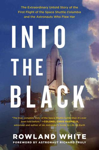
Into the Black: The Extraordinary Untold Story of the First Flight of the Space Shuttle Columbia and the Astronauts Who Flew Her by Rowland White, Richard Truly
Albert Einstein, Apollo 11, Apollo 13, Apollo Guidance Computer, Ayatollah Khomeini, Berlin Wall, Boeing 747, Charles Lindbergh, cuban missile crisis, Easter island, Fall of the Berlin Wall, Gene Kranz, Isaac Newton, it's over 9,000, John von Neumann, low earth orbit, Maui Hawaii, Mercator projection, Neil Armstrong, orbital mechanics / astrodynamics, Ronald Reagan, Strategic Defense Initiative, William Langewiesche
His movement restricted by the layers of his Nomex pressure suit, Young reached forward to the coaming above the instrument panel and punched a button to switch the orbiter’s body flap from manual to automatic. SIXTY-THREE Houston, 1981 Inside Mission Control there was tension you could chew. The Mercator projection world map that had recorded Columbia’s orbital track around the globe on big screens in front of the consoles was taken down. In its place went a graphic showing the Shuttle’s velocity and ground track across the Pacific toward the West Coast. The former was also included in the flight dynamics data displayed in front of Joe Allen and Rick Hauck at CapCom.

pages: 497 words: 144,283
Connectography: Mapping the Future of Global Civilization by Parag Khanna
"World Economic Forum" Davos, 1919 Motor Transport Corps convoy, 2013 Report for America's Infrastructure - American Society of Civil Engineers - 19 March 2013, 9 dash line, additive manufacturing, Admiral Zheng, affirmative action, agricultural Revolution, Airbnb, Albert Einstein, amateurs talk tactics, professionals talk logistics, Amazon Mechanical Turk, Anthropocene, Asian financial crisis, asset allocation, autonomous vehicles, banking crisis, Basel III, Berlin Wall, bitcoin, Black Swan, blockchain, borderless world, Boycotts of Israel, Branko Milanovic, BRICs, British Empire, business intelligence, call centre, capital controls, Carl Icahn, charter city, circular economy, clean water, cloud computing, collateralized debt obligation, commoditize, complexity theory, continuation of politics by other means, corporate governance, corporate social responsibility, credit crunch, crony capitalism, crowdsourcing, cryptocurrency, cuban missile crisis, data is the new oil, David Ricardo: comparative advantage, deglobalization, deindustrialization, dematerialisation, Deng Xiaoping, Detroit bankruptcy, digital capitalism, digital divide, digital map, disruptive innovation, diversification, Doha Development Round, driverless car, Easter island, edge city, Edward Snowden, Elon Musk, energy security, Ethereum, ethereum blockchain, European colonialism, eurozone crisis, export processing zone, failed state, Fairphone, Fall of the Berlin Wall, family office, Ferguson, Missouri, financial innovation, financial repression, fixed income, forward guidance, gentrification, geopolitical risk, global supply chain, global value chain, global village, Google Earth, Great Leap Forward, Hernando de Soto, high net worth, high-speed rail, Hyperloop, ice-free Arctic, if you build it, they will come, illegal immigration, income inequality, income per capita, industrial cluster, industrial robot, informal economy, Infrastructure as a Service, interest rate swap, Intergovernmental Panel on Climate Change (IPCC), Internet of things, Isaac Newton, Jane Jacobs, Jaron Lanier, John von Neumann, Julian Assange, Just-in-time delivery, Kevin Kelly, Khyber Pass, Kibera, Kickstarter, LNG terminal, low cost airline, low earth orbit, low interest rates, manufacturing employment, mass affluent, mass immigration, megacity, Mercator projection, Metcalfe’s law, microcredit, middle-income trap, mittelstand, Monroe Doctrine, Multics, mutually assured destruction, Neal Stephenson, New Economic Geography, new economy, New Urbanism, off grid, offshore financial centre, oil rush, oil shale / tar sands, oil shock, openstreetmap, out of africa, Panamax, Parag Khanna, Peace of Westphalia, peak oil, Pearl River Delta, Peter Thiel, Philip Mirowski, Planet Labs, plutocrats, post-oil, post-Panamax, precautionary principle, private military company, purchasing power parity, quantum entanglement, Quicken Loans, QWERTY keyboard, race to the bottom, Rana Plaza, rent-seeking, reserve currency, Robert Gordon, Robert Shiller, Robert Solow, rolling blackouts, Ronald Coase, Scramble for Africa, Second Machine Age, sharing economy, Shenzhen special economic zone , Shenzhen was a fishing village, Silicon Valley, Silicon Valley startup, six sigma, Skype, smart cities, Smart Cities: Big Data, Civic Hackers, and the Quest for a New Utopia, South China Sea, South Sea Bubble, sovereign wealth fund, special economic zone, spice trade, Stuxnet, supply-chain management, sustainable-tourism, systems thinking, TaskRabbit, tech worker, TED Talk, telepresence, the built environment, The inhabitant of London could order by telephone, sipping his morning tea in bed, the various products of the whole earth, Tim Cook: Apple, trade route, Tragedy of the Commons, transaction costs, Tyler Cowen, UNCLOS, uranium enrichment, urban planning, urban sprawl, vertical integration, WikiLeaks, Yochai Benkler, young professional, zero day
BOX: Rivers over Borders How to Negotiate with Nature BOX: Measuring the Supply Chain’s Footprint Location, Location, Location CONCLUSION: FROM CONNECTIVITY TO RESILIENCE A New Moral Compass Networks That Run Themselves Building a Borderless World Recommended Sites and Tools for Mapping Map Insert Dedication Acknowledgments Notes Bibliography Map Credits and Sources By Parag Khanna About the Author PROLOGUE The natural consequence of any obsession is passing it on to one’s children. I’ve been collecting globes, maps, and other geographic artifacts since my itinerant childhood. Thus it is hardly a coincidence to have been writing portions of this book while methodically assembling a thousand-piece world map with my daughter. The map is a Mercator projection, named for the sixteenth-century Flemish geographer who sought to make maps more useful for navigation but in the process massively distorted the scale of the extreme latitudes. Hence my daughter exclaiming, “Greenland is so big!” (While also wondering why it was colored orange.) Africa was the easiest continent to piece together: With fifty-four countries, each little jigsaw shape was full of clues such as contrasting national colors and city names.

Globalists: The End of Empire and the Birth of Neoliberalism by Quinn Slobodian
"World Economic Forum" Davos, Alan Greenspan, Asian financial crisis, Berlin Wall, bilateral investment treaty, borderless world, Bretton Woods, British Empire, business cycle, capital controls, central bank independence, classic study, collective bargaining, David Ricardo: comparative advantage, Deng Xiaoping, desegregation, Dissolution of the Soviet Union, Doha Development Round, eurozone crisis, Fall of the Berlin Wall, floating exchange rates, full employment, Garrett Hardin, Greenspan put, Gunnar Myrdal, Hernando de Soto, invisible hand, liberal capitalism, liberal world order, Mahbub ul Haq, market fundamentalism, Martin Wolf, Mercator projection, Mont Pelerin Society, Norbert Wiener, offshore financial centre, oil shock, open economy, pattern recognition, Paul Samuelson, Pearl River Delta, Philip Mirowski, power law, price mechanism, public intellectual, quantitative easing, random walk, rent control, rent-seeking, road to serfdom, Ronald Reagan, special economic zone, statistical model, Suez crisis 1956, systems thinking, tacit knowledge, The Chicago School, the market place, The Wealth of Nations by Adam Smith, theory of mind, Thomas L Friedman, trade liberalization, urban renewal, Washington Consensus, Wolfgang Streeck, zero-sum game
In the text, he called it an icon of “the freedom to sell in the market place.”82 The fact that Rivera was a card-carrying Communist best known for his workerist murals was no obstacle to Petersmann’s misrepresentation of Rivera’s work to reinforce his own dedication to market rights as the most fundamental of human rights.83 A more fitting choice was made by Lamy for his book on the Geneva Consensus: one of the newer paintings that decorated the WTO’s walls, from the Danaé World Suite, 2001 by Jean-Claude Prêtre. The painting shows a Mercator projection of the world beneath a grid of crosses and flecks of 282 GLOBALISTS The world at the edges of representation. Pascal Lamy, The Geneva Consensus: Making Trade Work for All (Cambridge: Cambridge University Press, 2013). Reprinted by permission of the publisher. colorful paint. Barely visible underneath are the outlines of the continents.

pages: 650 words: 155,108
A Man and His Ship: America's Greatest Naval Architect and His Quest to Build the S.S. United States by Steven Ujifusa
8-hour work day, big-box store, British Empire, Charles Lindbergh, company town, computer age, Cornelius Vanderbilt, glass ceiling, haute cuisine, interchangeable parts, Malcom McLean invented shipping containers, Mercator projection, Ronald Reagan, the built environment, trade route
Marckwald, who derided what she called the traditional “elk horn” style, could not panel the walls with oak or mahogany, nor could she hang its windows with heavy velvet curtains. Plus she abhorred “muddy” colors. On United States, she had the smoke room walls painted jet black and covered the windows (which overlooked the enclosed promenade) with plaid drapery. For the room’s centerpiece, William King created a simple aluminum Mercator projection of the world for the forward bulkhead. Small clocks positioned above each meridian showed the times of day around the world. A well-stocked bar was placed on the opposite side of the room. Chairs and couches upholstered in red leather—fireproofed, of course—completed the clubby look. It was not quite New York’s University Club or London’s Royal Automobile Club, but it was close enough considering the restrictions.

pages: 542 words: 163,735
The City and the Stars / The Sands of Mars by Arthur C. Clarke
AOL-Time Warner, British Empire, Colonization of Mars, hydroponic farming, Mercator projection, Stephen Hawking
Only 6,000 kilometers from the surface of the planet, and with a gravity less than a thousandth of Earth’s, it was ideal for this purpose. The Ares was due to dock in less than a week, and already Mars was a small disc showing numerous surface markings even to the naked eye. Gibson had borrowed a large Mercator projection of the planet and had begun to learn the names of its chief features— names that had been given, most of them, more than a century ago by astronomers who had certainly never dreamed that men would one day use them as part of their normal lives. How poetical those old mapmakers had been when they had ransacked mythology!

pages: 1,197 words: 304,245
The Invention of Science: A New History of the Scientific Revolution by David Wootton
agricultural Revolution, Albert Einstein, book value, British Empire, classic study, clockwork universe, Commentariolus, commoditize, conceptual framework, Dava Sobel, double entry bookkeeping, double helix, en.wikipedia.org, Ernest Rutherford, Fellow of the Royal Society, fudge factor, germ theory of disease, Google X / Alphabet X, Hans Lippershey, interchangeable parts, invention of gunpowder, invention of the steam engine, invention of the telescope, Isaac Newton, Jacques de Vaucanson, James Watt: steam engine, Johannes Kepler, John Harrison: Longitude, knowledge economy, Large Hadron Collider, lateral thinking, lone genius, Mercator projection, On the Revolutions of the Heavenly Spheres, Philip Mirowski, placebo effect, QWERTY keyboard, Republic of Letters, social intelligence, spice trade, spinning jenny, Suez canal 1869, tacit knowledge, technological determinism, the scientific method, Thomas Kuhn: the structure of scientific revolutions
Loth to goe up the hill, or labour thus To goe to heaven, we make heaven come to us.82 European world maps placed Europe at the centre, but when the Chinese were shown a world map by Matteo Ricci and complained that China should be at the centre, he promptly produced a new map which did just that.xix Mercator’s projection (1599), when used to produce a world map, shrinks countries close to the equator and makes the northern countries appear much larger than they really are, but this is an entirely accidental consequence of constructing a projection which enables a course plotted on a chart to be used directly for navigational purposes; the Mercator projection, which shows a three-dimensional globe on a flat surface, distorts distances in order to preserve accuracy when it comes to directions. These maps were originally intended as tools for sailors, not assertions of European supremacy; they look like ideological statements only to people who do not use them for navigation.

pages: 913 words: 299,770
A People's History of the United States by Howard Zinn
active measures, affirmative action, agricultural Revolution, Alan Greenspan, Albert Einstein, American ideology, anti-communist, Bartolomé de las Casas, Bernie Sanders, British Empire, classic study, clean water, colonial rule, company town, Cornelius Vanderbilt, cotton gin, death from overwork, death of newspapers, desegregation, equal pay for equal work, feminist movement, friendly fire, full employment, God and Mammon, Herman Kahn, Howard Zinn, Ida Tarbell, illegal immigration, jobless men, land reform, Lewis Mumford, Mercator projection, Mikhail Gorbachev, military-industrial complex, minimum wage unemployment, Monroe Doctrine, new economy, New Urbanism, Norman Mailer, offshore financial centre, plutocrats, profit motive, Ralph Nader, Ralph Waldo Emerson, RAND corporation, Ronald Reagan, Rosa Parks, Savings and loan crisis, scientific management, Seymour Hersh, Silicon Valley, strikebreaker, Telecommunications Act of 1996, The Wealth of Nations by Adam Smith, Timothy McVeigh, transcontinental railway, Triangle Shirtwaist Factory, union organizing, Upton Sinclair, very high income, W. E. B. Du Bois, War on Poverty, work culture , Works Progress Administration
The historian’s distortion is more than technical, it is ideological; it is released into a world of contending interests, where any chosen emphasis supports (whether the historian means to or not) some kind of interest, whether economic or political or racial or national or sexual. Furthermore, this ideological interest is not openly expressed in the way a mapmaker’s technical interest is obvious (“This is a Mercator projection for long-range navigation—for short-range, you’d better use a different projection”). No, it is presented as if all readers of history had a common interest which historians serve to the best of their ability. This is not intentional deception; the historian has been trained in a society in which education and knowledge are put forward as technical problems of excellence and not as tools for contending social classes, races, nations.
pages: 1,773 words: 486,685
Global Crisis: War, Climate Change and Catastrophe in the Seventeenth Century by Geoffrey Parker
agricultural Revolution, British Empire, classic study, Climatic Research Unit, colonial rule, creative destruction, currency manipulation / currency intervention, Defenestration of Prague, Edmond Halley, en.wikipedia.org, European colonialism, failed state, Fellow of the Royal Society, financial independence, friendly fire, Google Earth, Intergovernmental Panel on Climate Change (IPCC), Isaac Newton, it's over 9,000, Johannes Kepler, Joseph Schumpeter, Khyber Pass, mass immigration, Mercator projection, moral hazard, mortgage debt, Peace of Westphalia, Peter Thiel, public intellectual, Republic of Letters, sexual politics, South China Sea, the market place, trade route, transatlantic slave trade, unemployed young men, University of East Anglia, World Values Survey, zero-sum game
The victors then undertook campaigns of conquest that eventually created a state twice as large as Ming China and endured for two centuries. No other political change in the mid-seventeenth century affected so many people, caused so much damage, or created such lasting consequences. 16. Ming China and its neighbours. Most maps of East Asia use Mercator's projection, which increases the size of Ming China compared with the steppes where the Manchu dynasty achieved dominance in the early seventeenth century. In 1644, the Great Wall failed to protect Beijing (the Ming northern capital) from capture, first by a bandit army from the west and then by the Manchus from the north.